
Slow-slip event off the east coast has now finished
Earlier this year, GeoNet’s GPS network recorded a large slow-slip event off the east coast of the North Island. Since about early June, this activity has tapered off.
Some of you have been asking ‘what’s going on?’ with that slow-slip event, so we thought it would be good to provide an update. The East Coast slow-slip event finished up about 3 weeks ago, in mid-June 2019.
The slow-slip event began offshore of Gisborne during the last week of March and spread southward towards offshore Hawke’s Bay. You might remember that the movement during the event slowed down for a few weeks in April before picking back up again in the Hawke’s Bay region at the beginning of May.
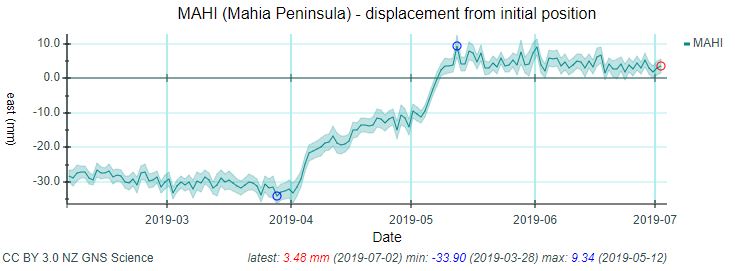
Timeseries plot showing displacement at Mahia Peninsula. You can see the plate movement slowed for a few weeks before picking up again.
During the slow-slip event, we recorded many small-to-moderate earthquakes in the area, including a M5.1 on 14 May. While these quakes have also tapered off, a model showing the evolution of the event indicates that many of the earthquakes appear to track the slow-slip movement.
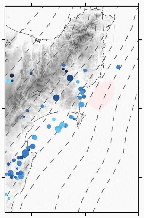
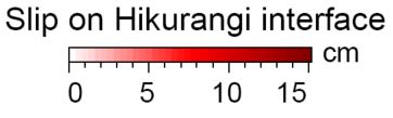
East Coast 2019 slow-slip event animation
Scale bar for Pacific Plate movement
This animation shows movement on the Hikurangi subduction plate boundary during the 2019 East Coast slow-slip event and associated earthquakes. It shows that the event started offshore Gisborne and moved south to Hawke’s Bay. Deeper red indicates increased rates of slow slip movement. See colour scale bar showing amount of movement on the plate boundary during each week-long snapshot. Models prepared by VUW PhD student, Katie Woods.
Our scientists currently have over two dozen instruments beneath Poverty Bay and Hawke Bay that are recording seafloor movement and earthquakes during slow-slip events. In November, these instruments will be collected and the data they provide will help give us a better picture of what happened during this event.
Total movement along the Hikurangi Subduction Zone during this slow-slip event is estimated to be about 20-30 cm, which is equivalent to roughly four-to-five years of plate motion there. To look at it another way, if this had ruptured in a single, instantaneous fault rupture (or what we consider a typical earthquake), it would likely have been similar to a M7.0 earthquake.
What happened?
Our scientists had been anticipating this slow-slip event – that’s why we have instruments on the seafloor right now recording movement. Our slow-slip record has shown regular events every 1-2 years with much larger events every 4-6 years. This most recent slow-slip event appears to be the largest event we’ve seen offshore the east coast and is slightly larger than the 2010 Gisborne slow-slip event (previously the largest we have observed in that area).
Slow-slip events are quite common in this part of New Zealand, due to the subducting Pacific Plate moving westward under the Australian Plate. We started detecting slow-slip events in 2002 after installing a GPS (Global Positioning System) network around New Zealand to monitor land movement.
Slow-slip events (sometimes called silent earthquakes) are undetectable by both humans and our seismograph network because they move faults over weeks to months instead of within seconds like the earthquakes that you typically think of.
For our previous updates on this slow-slip event, visit these links:
Slow-slip event off the coast of Gisborne
East Coast slow-slip event update
Last night’s M5.1 quake off the east coast of the North Island
Attributable to - Laura Wallace – GNS Science Geophysicist
Media enquiries - media@gns.cri.nz or 021 574 541