
We know you don’t like our ghost quakes, so we are fixing that for you
Good-bye ghost quakes! Starting next week, every quake listed on our website/app will have been reviewed by one of our Geohazards Analysts – that way only real quakes get reported.
Our seismic network was designed to measure on-shore earthquakes and although our sensitive equipment does pick up seismic waves from large distant events, when these seismic waves arrive in New Zealand, our automated system tries to place the earthquake somewhere local. This can produce a false event or ‘Ghost quake’ and while we do try to quickly fix these automatic events, they do cause concern and confusion. This has been happening a fair amount recently with the large Kermadec earthquakes we have been locating.
Over seven years ago all earthquakes were manually reviewed by a duty officer before they were posted to our website, this could sometimes take over twenty minutes! We then introduced our automated system which enabled earthquakes to show on our website (and app) only minutes after shaking started. Although this meant information was pushed out before a duty officer was available to review the event. So, it was an accepted trade-off between speed and accuracy, with speed accepted as the priority.
We now have the National Geohazards Monitoring Centre (NGMC) which is staffed by Geohazards Analysts (GHAs) who have their eyes on our network 24/7. So, we have decided that an earthquake solution (its magnitude, depth and location) must be reviewed by hand, by a GHA in all instances now. This means that quake information will not be displayed on the website, app or social media (Twitter) until it has undergone a preliminary review by a GHA, so no more ‘ghost quakes’.
Our team of GHAs are pretty speedy and most of the time this is done within a minute! And the majority are reviewed and posted to the website within five minutes. We understand people have become accustomed to almost instantaneous reporting, however we want to make sure that all our information is correct, as fast as possible. So now instead of choosing between speed and accuracy, we can have both!
While you will have a short wait for confirmed earthquake data, you can still get instant information from our website and app. On our home page we have Shake Map, which displays both earthquakes and recorded shaking in New Zealand in real time, for the past hour. The earthquake location will show up as a circle on the map, and where it was felt by humans and measured by seismometers are displayed as squares on the map. You can also view this on the GeoNet App by selecting ‘shaking in the last hour’.
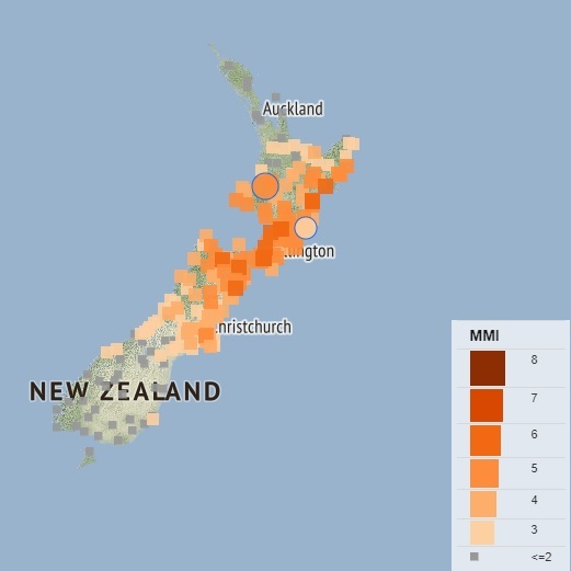
Shaking from a 2018 earthquake in Taumaranui.
For those after more instant technical information, you can also view our strong motion map which displays the peak strong motion data that GeoNet has collected during the last hour. Each strong motion site is shown on the map as a square, and any earthquakes in the last hour are superimposed as circles, these are coloured and scaled to show the size of the earthquakes and the ground motion, so with a quick glance you can see how much shaking has (or hasn't) been produced by an earthquake.
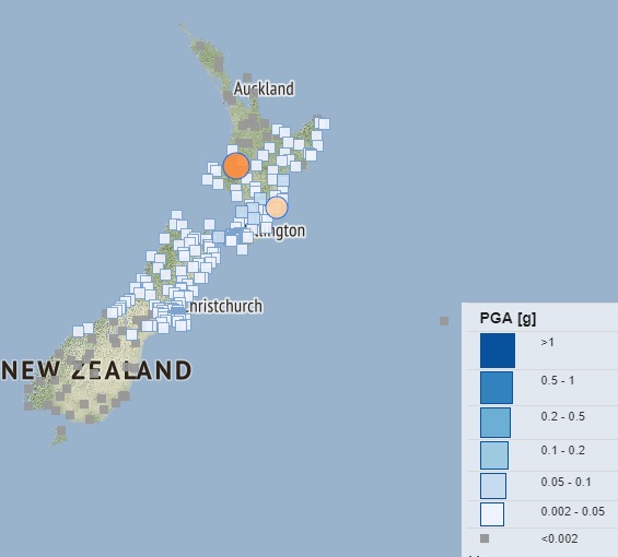
Strong motion data from a 2018 earthquake in Taumaranui.
If you click on one of the strong motion sites you’ll see the horizontal and vertical Peak Ground Velocity (PGV) and Peak Ground Acceleration (PGA) measurements, as well as the peak Modified Mercalli Intensity (MMI) value recorded at that site in the last hour.
The team at GeoNet are committed to ensuring that we provide New Zealanders with accurate geohazard information as fast as we can, and we hope you will welcome the change to ensure every earthquake you see on our website is a real event.
Media enquiries - media@gns.cri.nz or 021 574 541