
Update on slow-slip activity on the East Coast
Last month we shared that a slow-slip event was underway off the East Coast near Pōrangahau. That event wrapped up in late May, and our GPS stations further north near Gisborne have since detected another event.
Even though these two East Coast slow-slip events are a couple of hundred kilometres apart, we often see such events clustering in time. For example, a series of slow-slip events like this occurred in 2011 and 2016.
Gisborne slow-slip event
The new slow-slip event near Gisborne looks to have started around 14 June and models suggest several centimetres of movement has occurred at the plate boundary so far. We have measured about 2cm of eastward displacement at the on-land GPS site at Gisborne.
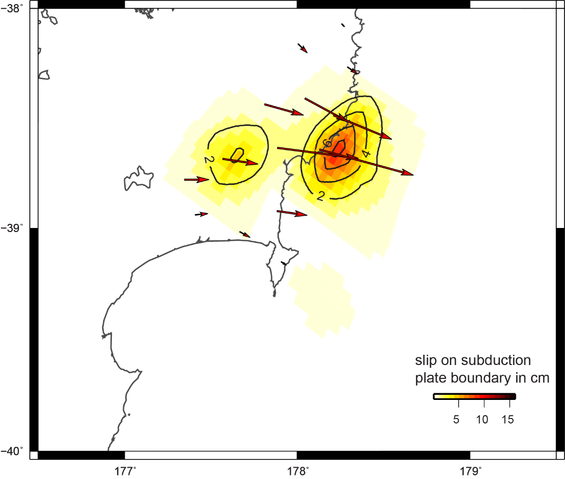
Slow-slip movement model showing direction of movement of GeoNet GPS sites and amount of displacement at the plate boundary.
This slow-slip event is visible on the Gisborne and Carnagh Station continuous GPS eastward movement plots on our slow-slip watch page. Data users can also see the events on FITS API plots.
The below graphs show the east component of the GPS site positions since July 2020.
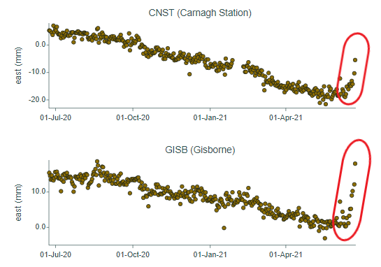
East component of the GPS site positions since July 2020.
The slow-slip record at Gisborne has shown regular events every 1-2 years with much larger events every 4-6 years.
The last event of a similar size near Gisborne occurred in April – June 2019.
During that slow-slip event, we recorded many small-to-moderate earthquakes in the area, including a M5.1 quake near Mahia Peninsula. We expect to see a similar pattern of small earthquakes near Gisborne for this current slow-slip event, in line with what has been observed during previous events.
Over the past two weeks we have observed a cluster of about 60 small earthquakes north of Gisborne, coincidental to the timing of the slow-slip event. Five of these have been over M3. The largest was a magnitude 4.2 on Wednesday 16 June that wasn't widely felt (we had 123 felt reports). Most of these events have been unnoticeable.
We’re keeping an eye on this data to better understand the possible relationship between the recent earthquake cluster and the slow-slip event.
Pōrangahau slow-slip event
The Pōrangahau event continued for about two weeks and finished up in early June. Our scientists had been anticipating the Pōrangahau slow-slip event, as there is a record of one happening in the region about every five years.
Slow-slip events in New Zealand are typically associated with increased numbers of small earthquakes. We located 50% more earthquakes in the Pōrangahau region in the last month than we would normally locate.
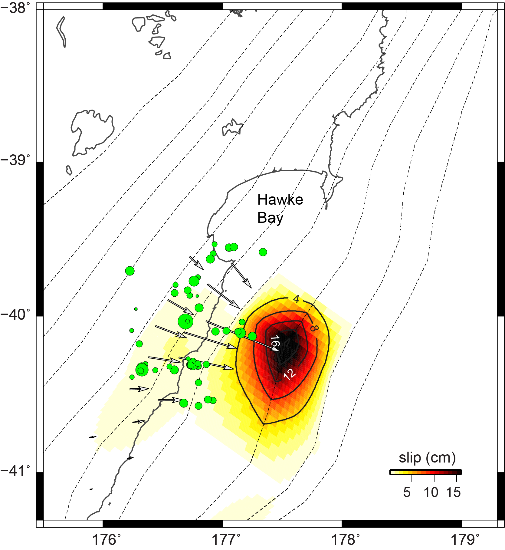
Slow-slip movement model showing direction of movement of GeoNet GPS sites and amount of displacement at the plate boundary. Green dots show earthquakes over the past week in that area.
Studying slow-slip events
Slow-slip events are undetectable by both humans and our seismograph network because they move faults over weeks to months instead of within seconds like normal earthquakes.
Scientists can use displacement data from GeoNet GPS sites on the earth’s surface to figure out how much movement has occurred on the Hikurangi Subduction Zone below the eastern North Island.
Currently, there are many seismic and geodetic instruments deployed along the East Coast capturing data from slow-slip events. Insights from this data will help scientists better understand what drives slow-slip activity and could aid in future monitoring to forecast large earthquakes.
If you want to read more about slow-slip events, read our previous story here.
Slow-slip events are a great reminder that we live on a very active tectonic plate boundary here in New Zealand.
In the event of a large earthquake: Drop, Cover and Hold. If you are near the coast and you feel a Long OR Strong earthquake, get to higher ground or as far inland as you can once the shaking has stopped in case a tsunami was generated. For more information on how to get prepared, visit the National Emergency Management Agency’s website getready.govt.nz.
Attributable to - Laura Wallace – GNS Science Geophysicist
Media enquiries - media@gns.cri.nz or 021 574 541