Mt Ruapehu’s Te Wai ā-moe (Crater Lake) is now cooling. Volcanic activity remains low, and the Volcanic Alert Level remains at Level 1.
After a short heating phase starting mid-July this year, Te Wai ā-moe (Ruapehu Crater Lake) has now cooled back down. Other monitoring indicators are within normal ranges for Mt Ruapehu. Volcanic activity remains low. The Volcanic Alert Level remains at Level 1 and the Aviation Colour Code at Green.
In mid-July 2023 the temperature of Te Wai ā-moe (Crater Lake) started a rising trend, lasting through to early September when a cooling phase started. The lake temperature rose from 11 °C to 26 °C and has now cooled to around 14 °C (Figure 1). The heat flow into the lake is currently around 30-60 MW, typical of a cooler lake.
The lake can experience temporary drops in temperature due to short-lived input of snow melt and heavy rainfall into the lake. These short-term variations did not affect the long-term heating or cooling trends.
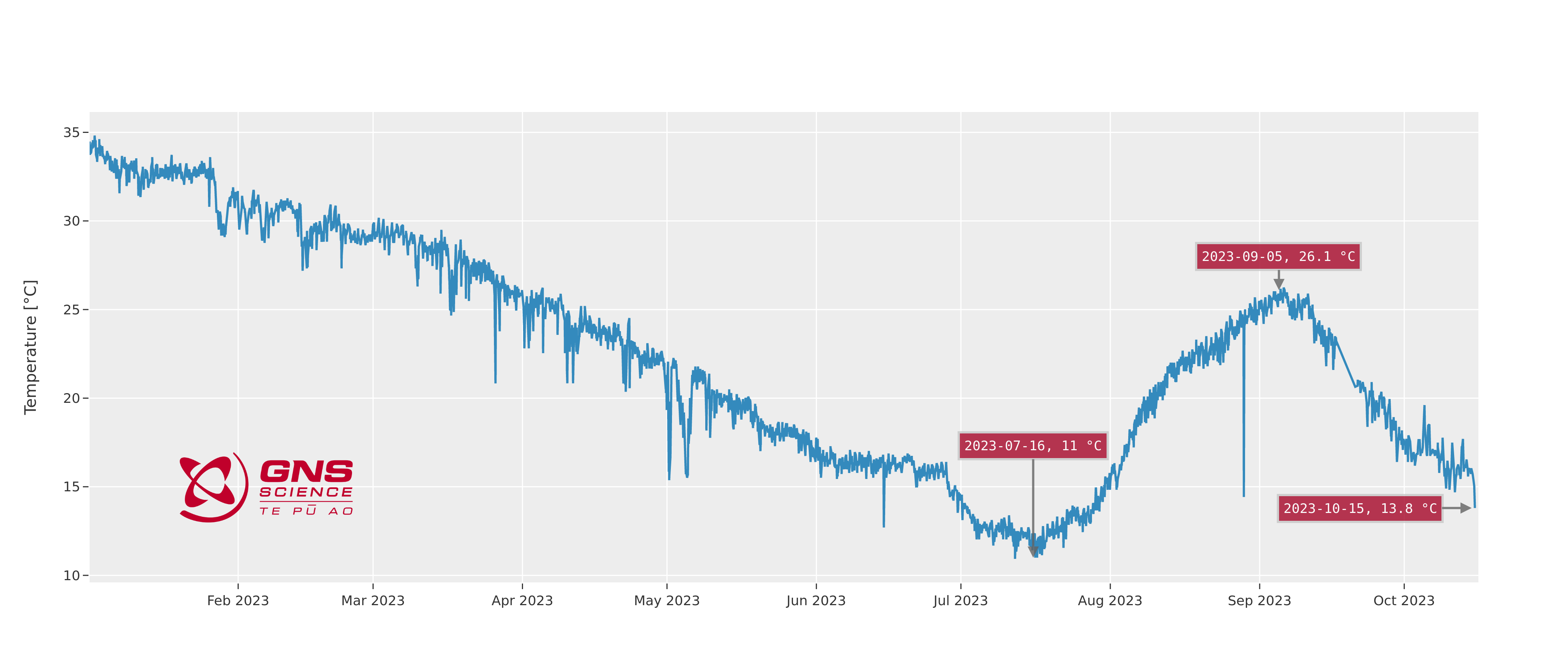
Figure 1. The temperature of Te Wai ā-moe (Crater Lake) from January to mid-October 2023. Short-lived drops in temperature are due to rain or snow melt events.
Water and gas samples were collected from the lake on October 5, 2023. Chemical analyses of these samples are within the range of recent chemistry samples. Key gas indicators suggest the temperature of the gas deeper in the magmatic system has increased, which has not currently affected the temperature of the lake. Areas of upwelling (discoloured water) and yellow sulphur slicks on the lake surface indicate water and gas flows into the lake from below (Figure 2).
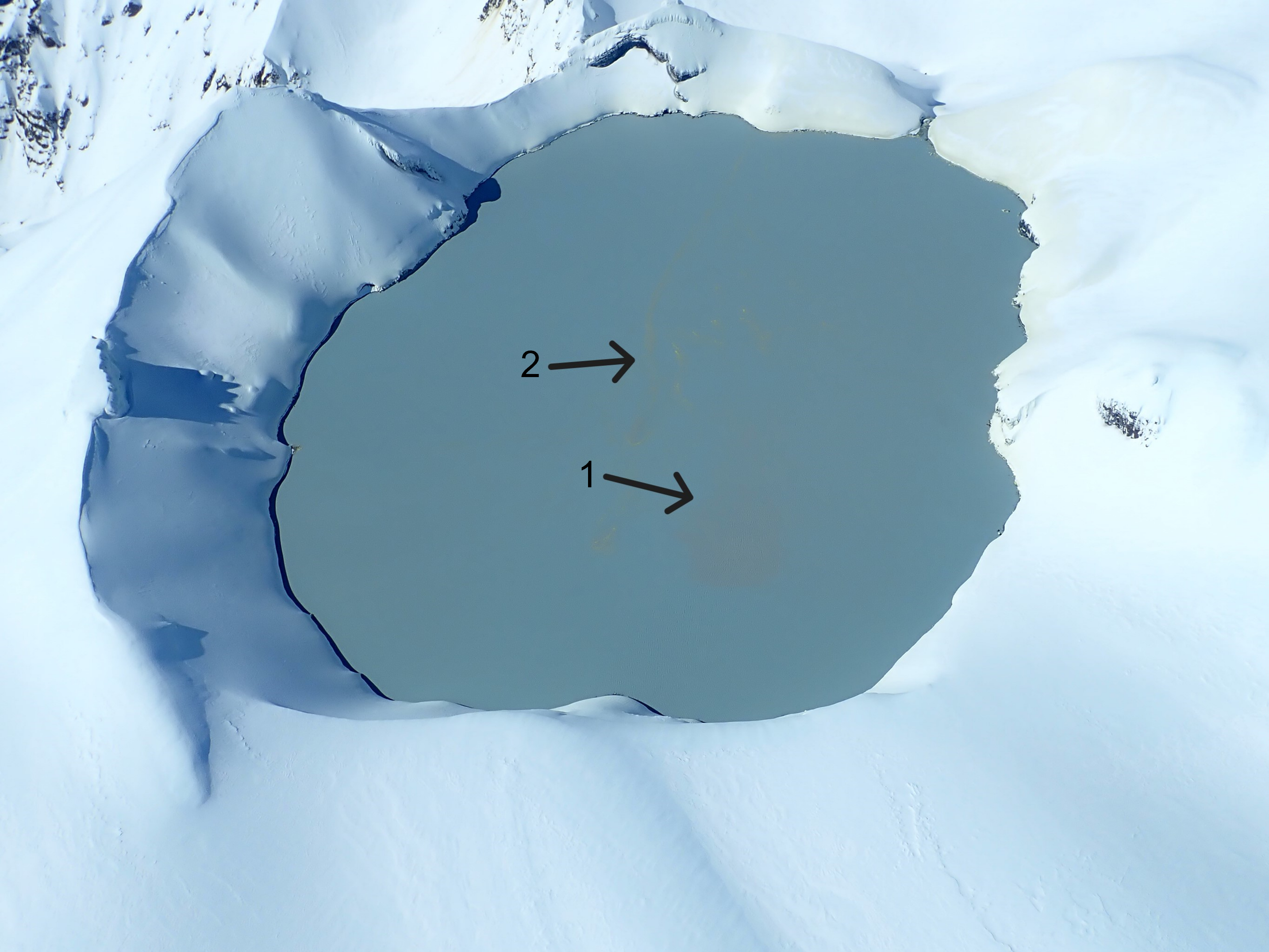
Figure 2: Aerial view of upwell area (darker grey, labelled 1) and sulphur slicks (labelled 2) on lake surface 5 October.
Since installation, our new scanDOAS gas scanning equipment has measured low-to-moderate levels of SO2 gas output most days. Since late September the amount of gas detected has declined, however volcanic gases are still flowing through the volcano.
The level of volcanic tremor recorded by our seismic equipment has remained weak during 2023, and a few earthquakes have been located beneath or near the volcano.
In summary, the falling lake temperature is similar to past cooling phases at Mt Ruapehu. Gas and water chemistry measurements, visual observations of upwelling and sulphur slicks, and low levels of SO2 gas output suggest that the volcanic vents beneath Te Wai ā-moe (Crater Lake) are at least partially open and allow volcanic gases and fluids to enter the lake. This is supported by the currently weak volcanic tremor, and is consistent with a low level of volcanic activity overall. As a result, the Volcanic Alert Level remains at Level 1. The Aviation Colour Code remains Green.
While it is currently quiet overall (minor volcanic unrest), Mt Ruapehu remains an active volcano, with the potential to erupt with little or no warning.
The Volcanic Alert Level reflects the current level of volcanic unrest. The Volcanic Alert Level should not be used to forecast future activity.
Volcanic Alert Level 1 indicates the primary hazards are those expected during volcanic unrest: steam discharge, volcanic gas, earthquakes, landslides, and hydrothermal activity. While Volcanic Alert Level 1 is mostly associated with environmental hazards, potential for eruption hazards also exists and eruptions can still occur with little or no warning. Volcanic Alert Levels 3, 4 and 5 are reserved for eruptions with varying impact distances.
For information on access to the Mt Ruapehu area, please visit the Department of Conservation’s website on volcanic risk in Tongariro National Park and follow the DOC Tongariro Facebook page for further updates.
For information about responding to volcanic activity there are guidelines from the National Emergency Management Agency.
GNS Science and its National Geohazards Monitoring Centre continue to closely monitor Mt Ruapehu for further changes.
Yannik Behr
Duty Volcanologist
Media Contact: 021 574 541 or media@gns.cri.nz