Earthquake activity continues and deformation observed at Taupō. Volcanic Alert Level remains at Level 0
The earthquake sequence beneath Lake Taupō continues. Ongoing ground deformation indicates a deformation source coincident with the seismically active region. The Volcanic Alert Level for Taupō Volcanic Centre remains at Level 0.
The earthquake sequence beneath the central part of Lake Taupō (Taupō-nui-a-Tia), that we reported on in our previous Volcanic Activity Bulletin, has continued at a rate of ~30 earthquakes per week. Since the start of the sequence in May 2022 this rate has been more or less constant, and we have now located over 490 earthquakes at less than 30 km depth.
Figure 1 shows earthquake locations for this sequence are forming two clusters in the central part of the lake. The smaller, western cluster is centred around Karangahape Cliffs and the larger, eastern cluster north-east of Horomatangi Reef. Shown in Figure 2 is the number of earthquakes detected and located in the dashed area outlined in the map each year since 2000. The two largest earthquakes since May were both magnitude 3.6, the first recorded on 17 May and the other on 11 July.
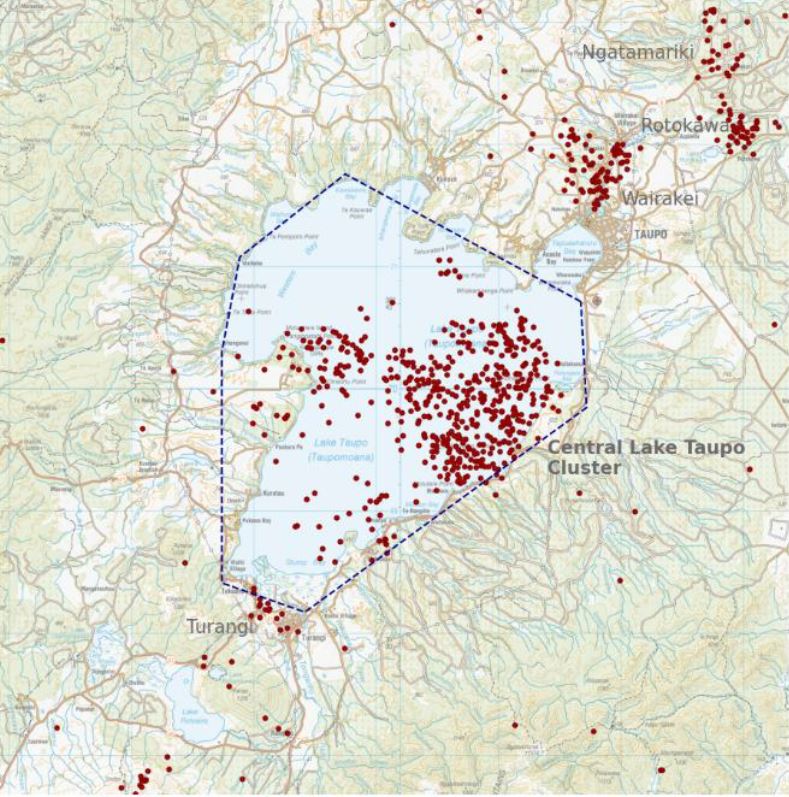
Figure 1: Earthquakes located by GeoNet in the Lake Taupō area from January 1 to August 21, 2022. All earthquakes shown here were located less than 30 km deep. There are over 400 earthquakes shown on the map.
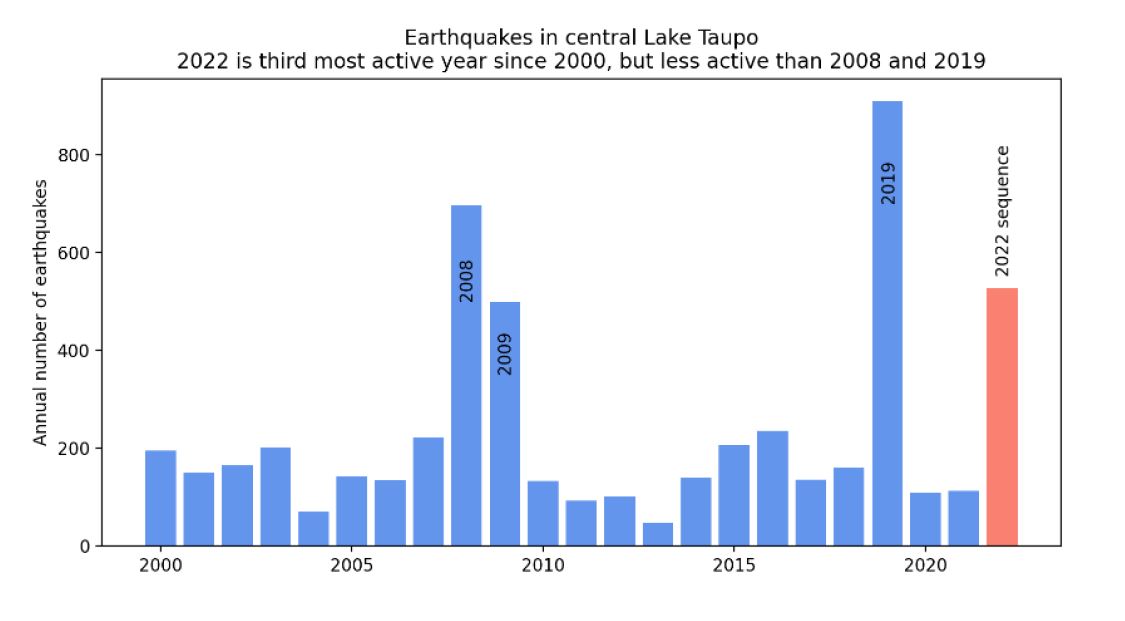
Figure 2: Earthquakes detected and located in the dashed area outlined in the map each year since 2000. The 2022 sequence of earthquakes stands out, but at this stage has fewer earthquakes than the 2008-2009 and 2019 sequences.
GeoNet continuously monitors ground deformation about Taupō. In addition to the 12 mm uplift seen from lake levelling data, deformation measurements around the lake from GNSS (GPS) instruments also show a signal indicating horizontal deformation. Numerical modelling indicates that the horizontal extension is consistent with a deformation source within the main region of seismic activity.
Taupō Volcanic Centre is part of the Taupō Volcanic Zone, a tectonically very active region with many known faults and active volcanism. Activity in this region is often related to a mix of regional deformation processes and the magmatic system under the volcanoes. While the observations beneath Lake Taupō to date represent an increase to the normal background activity, they do not stand out with respect to previous periods of unrest in 2008-2009 and 2019 (see Figure 2). We believe that the 2022 earthquakes and ground deformation are similar to those of 2008-2009 and 2019, which has helped to inform our view that Volcanic Alert Level 0 is currently appropriate for the Taupō Volcanic Centre. Therefore, the Volcanic Alert Level remains at 0.
The Volcanic Alert Level reflects the current level of volcanic unrest or activity and is not a forecast of future activity. Volcanic Alert Level 0 indicates the primary hazards are volcanic environmental hazards that may include hydrothermal activity, earthquakes, landslides, volcanic gases, and/or lahars (mudflows). Further information about the Volcanic Alert Levels and what they mean can be found here.
Taupō is an active volcano and earthquakes, and uplift or subsidence will continue to occur in the future. GNS Science through the GeoNet programme continually monitors Taupō and our other active volcanoes for signs of activity.
Although we can’t prevent natural hazards, we can prepare for them – and we should.
For information on preparing for earthquakes or responding to volcanic activity, there are guidelines from the National Emergency Management Agency's Get Ready website.
Toka Tū Ake EQC have information for preparing your home for natural hazards.
Find out more about Taupō Volcano
How do we monitor our volcanoes?
Earthquakes can occur anywhere in New Zealand at any time. In the event of a large earthquake: Drop, Cover and Hold.
Yannik Behr
Duty Volcanologist
Media Contact: 021 574541 or media@gns.cri.nz
Footnote: You might notice we've made a tweak to the name of these bulletins - from Volcanic Alert Bulletin to Volcanic Activity Bulletin. We've done this because we think it better reflects the purpose of these bulletins, which can also include more general updates like this one. Any queries, please let us know.