Minor unrest continues at Taupō Volcano. Volcanic Alert Level remains at Level 1.
The minor volcanic unrest that began in May 2022 continues at Taupō Volcano. Small earthquakes and ground deformation are still being recorded at above background levels. The Volcanic Alert Level remains at 1 (minor volcanic unrest).
The aftershock sequence following the M5.7 earthquake on 30 November 2022 has finished.
The M5.7 generated a small tsunami within Lake Taupō, caused ~175 mm of horizontal and ~180 mm vertical ground movement at Horomatangi (Figure 1), and was followed by a month of aftershocks, with 758 recorded by 31 December 2022 (Figure 2).
Just under half (46%) of the earthquakes during the 2022/2023 unrest episode are associated with the 30 November 2022 main shock-aftershock sequence. The current rate of earthquakes occurring per week is similar to other times during this period of unrest, indicating minor unrest continues (Figure 3).
Ground deformation (land movement) continues around Lake Taupō, which we measure using GNSS (GPS) instruments and lake levelling surveys. The Horomatangi Reef site continues to move after the 30 November 2022 M5.7 earthquake towards the south-east (Figure 1).
Figure 1
GNSS ground movement towards the east (green circles, top panel) and vertically (red circles bottom panel) observed at Horomatangi Reef in central Lake Taupō since mid-September 2022 (the crosses in both panels are data points we cannot use). The observations represent the average of eight hours of data. The scatter in the observations reflects the uncertainty in the calculated values. The big change in movement was caused by the M5.7 earthquake, shown by the vertical dashed line labelled “M5.7”. The more subtle movement before and after this is the ground movement associated with unrest – it is hard to see, but if you compare the horizontal line in the top panel after the M5.7 line, you can see the data points are moving away from it, showing the ground is moving to the east.
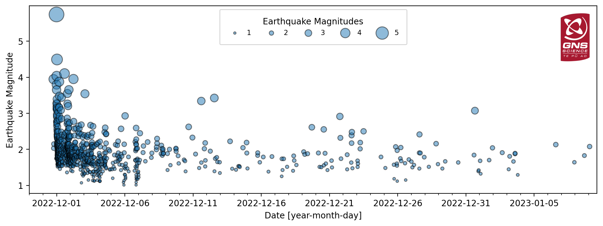
Figure 2
Aftershock timeseries since the M5.7 earthquake on 30 November 2022 to 31 December 2022. Each circle is an individual earthquake detected and located by the GeoNet network under Lake Taupō. The size of the circle indicates the magnitude of the earthquake.
Figure 3
Number of earthquakes detected and located by the GeoNet network beneath Lake Taupō each week since the start of 2022.
Through close partnership with the Tūwharetoa Māori Trust Board, Taupō District Council, and landowners, we improved our monitoring of Taupō volcano by installing some new equipment around the lake. Two new seismometers are allowing us to more accurately locate earthquakes, whilst two new instruments to measure ground movements are helping us better understand the processes driving the long-term deformation at Taupō volcano. Finally, we have installed a near real-time tsunami gauge to allow faster identification of the cause of potential future waves and tsunami.
This 2022/2023 unrest period at Taupō volcano is the most recent of 18 historic unrest episodes in the past 150 years, none of which have ended in an eruption (Figure 4). The unrest is caused by processes associated with magma and magma-related hot water, gas, and steam deep under the volcano generating earthquakes and ground movement. GNS Science continues to actively monitor the volcano.
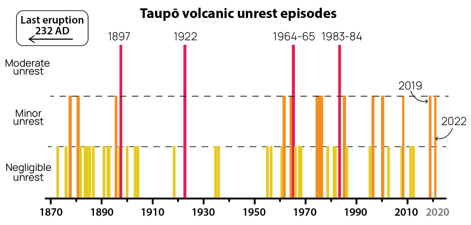
Figure 4
The magnitude of past unrest episodes at Taupō Volcano.
The Volcanic Alert Level reflects the current level of volcanic unrest or activity and is not a forecast of future activity. While Volcanic Alert Level 1 is mostly associated with environmental hazards, potential for eruption hazards also exists. Further information about the Volcanic Alert Levels and what they mean can be found here. More information about caldera unrest can be accessed from this report.
Ery Hughes (she/her)
Duty Volcanologist
Media Contact: 021 574541 or media@gns.cri.nz
The Tūwharetoa Māori Trust Board (CEO Rakeipoho Taiaroa) is closely involved in discussions as the landowner of Lake Taupō. More information about the Trust can be found at https://www.tuwharetoa.co.nz/.
Although we can’t prevent natural hazards, we can prepare for them – and we should.
Know what warning signs to look out for, so you can act quickly. Drop, Cover, and Hold during a large earthquake. If it is Long or Strong, Get Gone! People near the lake front should move to higher ground as soon as it is safe to do so, especially if they hear loud noises or see unusual lake action during earthquake activity.
During volcanic activity, follow official advice provided by your local Civil Defence Emergency Management Group. More information about Civil Defence in the Taupō District can be found here.
For information on preparing for earthquakes or responding to volcanic activity, there are guidelines from the National Emergency Management Agency's (NEMA) Get Ready website.
Prepare your home. Protect your whānau.
There’s a lot we can do to make our homes safer and stronger for earthquakes. Toka Tū Ake EQC’s website has key steps to get you started.