
10-year anniversary of the M6.5 Lake Grassmere earthquake
Today is the ten-year anniversary of the 2013 M6.5 Lake Grassmere earthquake. Those who were in the Wellington and Marlborough regions back then will remember an unsettling time of earthquakes and the impacts they had on our lives.
The M6.5 Lake Grassmere earthquake occurred on Friday 16 August at 2:31pm 5km south-east of Seddon. The previous month there had been a M5.7 earthquake under Cook Strait on 18 July 2013, which was then followed by two earthquakes on 21 July, a M5.8 and then the M6.5 Cook Strait earthquake 10 hours later.
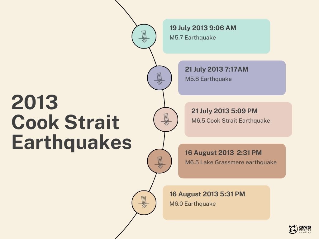
Timeline of the earthquake sequence
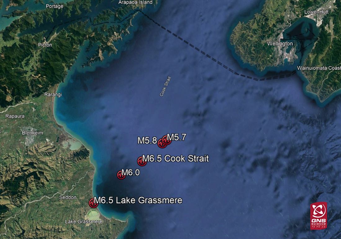
Locations of the five largest quakes
We spoke to GNS Seismologist Anna Kaiser who was the duty officer for both the M6.5 Cook Strait earthquake and the M6.5 Lake Grassmere earthquake. “One of the key things from a duty perspective, was that I could feel many of the earthquakes and ongoing aftershocks while responding on duty – so we had a ‘heads up’ before the official alert. We were experiencing these earthquakes along with the public and could relate to the many people that were feeling unsettled by this unusually high level of seismic activity.”
Anna said the shaking experienced in the upper South Island and in Wellington was the biggest that many people had felt at the time – and it caused some damage. Seddon and Ward, at the top of the South Island, experienced the strongest shaking during the earthquake.
Analysis of shaking data highlighted the role of sedimentary basins in amplifying the longer rolling motions and prolonging their duration.
“I know I experienced these motions here in Lower Hutt while at work, and that it was somewhat different to how the shaking was experienced by someone who was above solid rock where they would feel shorter, sharper shaking,” Anna explained.
“These types of ‘basin effects’ can occur around NZ where we have thicknesses of soils lying over rock.” The largest land shift was recorded at Cape Campbell, where land moved 18 cm to the west. Beneath the earth's surface, the maximum movement on the fault was approximately 3m which occurred 8km below Lake Grassmere. Observations by our geologists on the ground confirm that the fault rupture did not reach the land surface, as they did not find any evidence of a surface expression.
Why were there so many quakes here?
The Cook Strait is a very seismically active area of New Zealand, lying close to the Hikurangi subduction zone and other major crustal faults. It also marks a transition between the North Island and South Island fault systems. In the 10 years prior to the Cook Strait earthquake, GeoNet located around 2600 earthquakes in Cook Strait with depth under 40 km, many of them in the vicinity of the 2013 Cook Strait/Lake Grassmere earthquakes.
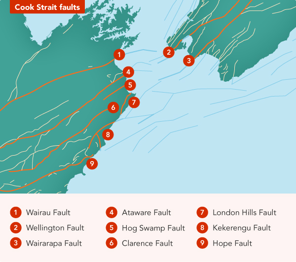
Map showing faults around Cook Strait
Here at GNS Science we are constantly improving our capacity and capability to monitor, measure, respond to and mitigate hazards with advancing global science and an expanding GeoNet network of cutting-edge monitoring equipment and technology.
Ten years on from the Cook Strait and Lake Grassmere earthquakes, the GNS Science hosted 'Rapid Characterisation of Earthquakes and Tsunami (RCET)' Programme is developing models and tools that can rapidly use this wealth of data to assess an earthquake as it happens. One of these tools, developed in partnership with GeoNet, will provide faster shaking maps to the public. So, if these earthquakes were to happen again today, we are better equipped to understand what has occurred.
Want to learn more?
Read: The Marlborough-Cook Strait faults
Read: Why do we get so many earthquakes
Earthquakes can occur anywhere in New Zealand at any time. In the event of a large earthquake: Drop, Cover and Hold.
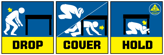
Drop, Cover and Hold
Remember Long or Strong, Get Gone : If you are near the coast and feel a strong earthquake that makes it hard to stand up OR a weak rolling earthquake that lasts a minute or more move immediately to the nearest high ground or as far inland as you can, out of tsunami evacuation zones.
Know what to do?
The National Emergency Management Agency (NEMA) has a great website with information on what to do before, during and after an earthquake.
Prepare your home. Protect your whānau.
There’s a lot we can do to make our homes safer and stronger for natural disasters. Toka Tū Ake EQC’s website has key steps to get you started.
Media Contact: 021 574 541 or media@gns.cri.nz