Earthquake activity recorded beneath Mt Ruapehu. Te Wai ā-moe (Crater Lake) slowly heating. Volcanic activity remains low, and the Volcanic Alert Level remains at Level 1.
The earthquake monitoring system at Mt Ruapehu has recently recorded a sequence of small earthquakes at 3-6 km depth clustered under the volcano. Te Wai ā-moe (Ruapehu Crater Lake) is slowly heating, currently reaching 19 °C. Other volcanic monitoring indicators remain within normal ranges. Volcanic activity remains low. The Volcanic Alert Level remains at Level 1 and the Aviation Colour Code at Green.
Between 21 and 26 November we located a sequence of 40 small earthquakes ranging in size from M0.3 to M1.8 beneath Mt Ruapehu (Figure 1). Earthquakes were located between 3 and 6 km beneath the volcano, with most in the 4-5 km range. Very similar earthquake activity was observed at the beginning of 2022 (RUA 2022/01).
Since mid-October, the temperature of Te Wai ā-moe (Crater Lake) has been slowly increasing, although it was impacted by recent rainfall. Past history shows that the lake temperature drops temporarily due to short-lived input of snow melt and heavy rainfall into the lake. These short-term variations do not affect the long-term heating or cooling trends. The heat flow into the lake is currently low at around 80 MW, typical of a cooler lake.
An observation flight on 22 November noted the lake colour had changed to a blue green from the more common grey colour seen in the last few months. No upwellings were observed, although sulphur slicks were seen on the lake surface and the lake was overflowing.
The level of volcanic tremor recorded by our seismic equipment has remained weak during 2023, with no response noted after the earthquakes. Since installation, our new scanDOAS gas scanning equipment has measured low-to-moderate levels of SO2 gas output most days.
The recent earthquakes under the volcano may be related to either a faulting process or the injection of new magma at depth under the volcano. The latter would increase the likelihood of an eruption, however, it is unclear from our monitoring data which process is driving the earthquake activity.
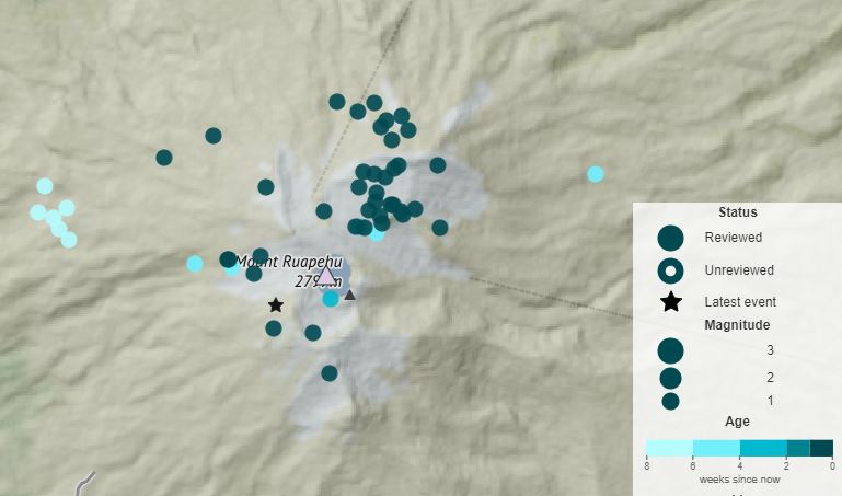
Figure 1: Earthquake locations (circles) beneath Mt Ruapehu. Darker coloured circles show earthquakes during the past week. Lighter coloured circles show older earthquakes.
The change in lake colour is consistent with less gas flow disturbing sediment at the base of the lake. Low to moderate gas flux values and lake temperatures that are low but slowly increasing indicate, however, that the lake vents are at least partially open.
Volcanic tremor, a key indicator of volcanic fluid movement, remains low and most other monitoring indicators are within normal ranges. Overall, this is consistent with a low level of volcanic activity. As a result, the Volcanic Alert Level remains at Level 1. The Aviation Colour Code remains Green.
Mt Ruapehu is an active volcano and has the potential to erupt with little or no warning when in a state of minor volcanic unrest.
The Volcanic Alert Level reflects the current level of volcanic unrest. The Volcanic Alert Level should not be used to forecast future activity.
Volcanic Alert Level 1 indicates the primary hazards are those expected during volcanic unrest: steam discharge, volcanic gas, earthquakes, landslides, and hydrothermal activity. While Volcanic Alert Level 1 is mostly associated with environmental hazards, potential for eruption hazards also exists and eruptions can still occur with little or no warning. Volcanic Alert Levels 3, 4 and 5 are reserved for eruptions with varying impact distances.
For information on access to the Mt Ruapehu area, please visit the Department of Conservation’s website on volcanic risk in Tongariro National Park and follow the DOC Tongariro Facebook page for further updates.
For information about responding to volcanic activity there are guidelines from the National Emergency Management Agency.
GNS Science and its National Geohazards Monitoring Centre continue to closely monitor Mt Ruapehu for further changes.
Yannik Behr Duty Volcanologist
Media Contact: 021 574 541 or media@gns.cri.nz